The location, site and situation significantly contribute to growth and function of a settlement. Location and surroundings could have positive and negative impact on settlement development. However, careful planning should be able to use well the advantages that the location of a town provides. Particularly location in the context of waterfront of sea, river and large lakes provides special resources, which can be effectively used for development of the town. Similarly, the town located on the hills provide other special opportunities for development. Any appraisal of the value and importance of a particular site must involve a knowledge of its historical past, evolution and landmarks of change.
The growth of clusters of urban settlements is more frequently found around large metropolises and results in what are sometimes called “city regions”. Often these are made up of small towns and villages, which have been enormously expanded as a result of national policy on dispersal of economic activities away from the metropolises. The small and medium towns in these city regions are related to one another by the functions, which they perform. Site condition in the hilly and mountainous regions may occupy site in: Ridges, Valleys, River terraces, Confluences, Rolling Meadows and in cases linear settlement growth along the major transportation routes or at the entrance to specific hill region.
5.2Guidelines for Study on Location, Site and situation of Settlement
5.2.1 Location
Location attributes to be considered in a planning exercise:
a) Location in terms of latitude and longitude, population size and area and connectivity with other settlements etc.
b) Nodal significance in the national or regional transport and communication network, power network and industrial development etc.
c) Location in terms of agricultural produce collection and distribution centre, agro-industries linked to local markets, irrigation network, agricultural extension services etc.
d) Status that the settlement in hierarchy in the State or the Region
e) Role and status of the city/ town in the national delivery systems of social services;
f) Relative significance of locations of city/ town in proximity to a Metropolitan/Megapolis:
i. Nodal significance
ii. Presence of high productive economic activities
iii. Presence of large scale market
5.2.2 Site
Site attributes to be studied for planning exercise:
a) Conditions of site: low-lying, swamp, or dry land, ridge, on a riverbank or canal side. Within the town-flat, slopping (in which direction), undulating-gentle slope, moderate slope, steep slope.
b) Value and importance of the site and its historical past, that is, when the nucleus was established.
c) Analyse the factors responsible for determining the site:
i. In alluvial plains
ii. In hilly and mountainous regions
iii. In arid regions
iv. In the areas of territorial ruler ship
v. In the areas around some localised physical resources, mining settlements, manufacturing towns, resort towns
vi. Around large metropolis
d) Climate and its influence on daily life, construction, range of crops and how the city activities have modified the natural climate, particularly in the built-up area.
e) Analysis of climate type, variations in temperature, wind velocity and wind directions in different parts of the city; study of the climate with reference to summer, rainy and winter seasons.
f) Limiting and the favourable factors of site in the spread and growth of the city/town.
5.2.3 Situation
The following to be considered for situation analysis:
a) The endowment of the situation (wider setting) for the subsequent growth in size of the city/town and for the enhancement of its functions
b) The important and interrelated aspects of situation, namely,
i. Physical configuration
ii. Route patterns
iii. The extent of the territory to which the urban functions are related
c) Suggest measures to retard or even overcome the weakening of the original value of the site and situation.
5.2.4 Hinterland
The endowment of the hinterland is another factor on which growth of an urban centre rests. An urban centre, for example, can establish a mutually interacting relationship with its hinterland if the hinterland has a variety and extent of natural resources in terms of both agriculture and economic potentials. A city's growth may be consistent and stable mainly because its economic base is closely linked with that of its hinterland. It is also conceivable that the city can be an instrument not merely for effectively utilising the existing potential of its hinterland but also of increasing the hinterland's potential itself. The development of the regional economy helps the growth of small towns, which in the process become the main service centres for their hinterlands.
Therefore, considerable attention should be given to the delimitation, functionality, social and economic link to a particular urban settlement. The area linked socially and economically to an urban settlement has been given various names, such as “Hinterland”, “Upland”, “Urban Field”, “Sphere of Influence”, “Zones of Influence”, “Tributary Area”, or “Catchment Area”. The immediate hinterland of a large city, which is directly under the influence of the agglomeration, is the ‘peri-urban area’.
5.2.4.1 Peri-urban area
The area influenced by a town is not a two-dimensional feature, not a sphere, nor does it necessarily form a continuous zone. Flow of goods, services and information into and
out of a town/city: most modern urban settlements and their immediate hinterlands are economically interdependent, rather than one being a tributary to the other. An analysis of the rural area served by a city/town gives some indication of the relation between city and the urban-rural mix (the peri-urban area), which is of practical application in examining the provision of goods and services in an urban centre. However, as mentioned in the Regional planning chapter, Peri-urban is the zone which is within the planning area limits but outside the limit of the municipal corporation / authority or metropolitan planning committee or authority.
As smaller towns fall within the areas served by larger metropolitan regions, the delimitation of urban zones of influence also sheds light on the manner in which a city at a particular level in the urban hierarchy provides specialist services for the surrounding population and settlements (such as service towns, satellite towns or service villages). Finally, very large cities extend a particularly intensive influence over the areas around them; so much so that these can be well defined peri-urban areas. Delimitation of peri-urban areas is directly influenced by accessibility as of highways and/or prime economic investments. With rapid urbanisation conditions, the peri-urban zone is dynamic. Hence peri-urban limits undergo alterations subject to high stress for urban growth and therefore always in fast transition.
In examining zone of influence, one commonly adopted method is to establish on a map the areas served by employment, shopping, entertainment, education, health services and so on. This method of analysis is applicable to cities and towns at all level in urban hierarchy. At a higher level in urban hierarchy the criteria used reflect the distinctive functions of larger settlements and employ information like:
The area served by the city's services and amenities like water supply, electricity, gas supply and telephone, health services, educational, cultural, recreational elements, security services such as police and fire brigades, postal services, mainly the local delivery areas and postal zones; banking and insurance facilities, the circulation of its daily newspapers.
- Flow of wholesale products, trip generation, intensity and speed of movement should be taken into consideration.
- Other reflective elements, which may be considered, are land use ratio of non-agricultural to agricultural population, density trends in population growth, settlement pattern, growth of built-up areas and pattern of communication.
In respect to a typical industrial town, its peri-urban area may be much more restricted than that of the other types of town. An intrusive industrial town may well not have the full range of urban services appropriate of its size. These missing functions will be supplied from other centres, thus making its zone of influence less clearly defined.
It will be clear that the analysis of urban zones of influence is most appropriate for those cities whose dominant role is that of serving as a central place, although most settlements of any reasonable size will have this among their various functions.
5.2.4.2 Leap Frog Development and Urban Sprawl
Leapfrog development refers to the occurrence of urban settlement in places separated from denser areas by open space and land under agricultural production. This development has “jumped” land unavailable for such development because it is held by the state, by other private owners, or because it is under the control of traditional authorities. This type of development may take the form of upmarket residential and business park development, or it may take the form of low-cost housing projects or informal settlements which may be implemented, or which may occur as a consequence of rapid urbanization 1 .
Urban sprawl refers to urban growth; along transportation routes in linear form with one or a few property depth as width on both sides of the road, taking advantage of accessibility, flow of goods and services. These urban developments have higher infrastructure systems cost such as water supply, power supply, which often have to be long extended from the nearest serving areas.
Municipal Planning & Management should apply careful control over change of agricultural land for non-agricultural uses. These conversions are commonly seen in peri-urban areas and are neither covered under Municipal laws not under any planning regulations as the location is outside the limits of municipality or even a planning authority.
Often, sporadic and scattered conversions create problems for future planned urban development, where many of these are done for speculation purposes to gain high capital returns from land lots. Though the laws require the land revenue authorities to take the advice of State Town Planning Department about viability before permitting conversions, but due to absence of any approved land use plan and weak structure of Town Planning Department, this step is rarely taken or even if taken it is hardly effective from planning perspective. Such haphazard urban sprawl needs to be curbed and regulations should be in place to discourage unplanned growth, which can be achieved through the Regional Planning Approach (see Chapter 4).
5.2.5 Accessibility
Accessibility is the dominant factor influencing the location, growth and functions of urban centres. It is to combine at least three elements: the location of a place within a region (in general, centrally located places are more accessible); the form of the transport system; and accessibility within the area of the activities: access to employment opportunities, access to population, access to educational or health facilities, etc.
1 Sustainable Urbanization: Guidelines to Manage Urban Growth, Volume 2: Tools and Guidelines, McIntosh Xaba& Associates.
Urban settlements tend to grow on transport routes only at specific places, particularly at junctions and break-of-bulk points, where one form of the transport is changed for another. Hence settlements whose locations are guided by transport routes are found not only at the end of these routes, but also along them. The number of routes, which come together at a particular point, is important, but the degree to which passengers and goods are interchanged is more important.
The guidelines for the study of accessibility are as under -
Establish the role of:
i. Long-distance regional/inter-regional transportation in determining the locations of the city/town;
ii. Both the long distance as well as local and intra-urban transportation in the growth of size of the city/town;
iii. Inter-urban and intra-urban transportation in affecting urban structure.
iv. Inter-regional easy access by different modes;
v. Good mobility within city/town due to construction of tunnel results in the development of new areas with commercial, industrial and residential activities, which leads to population increase in the entire urban area.
5.2.6 Socio-Economic Profile
City is not alone a characteristic of its physical or locational forms; its population and its characteristics determine the social processes that set the City culture. Socio-economic class-wise distribution of the population is a key indicator of the social parameters in a settlement. In case of existing settlement, the pattern of population on the basis of socio-economic levels can be studied for planning to understand the services and facilities. On the contrary, it is useful for the greenfield sites, where zoning can be proposed based on the income of the settling population class, higher, middle or low. Spatial plan is usually influenced by living and work places of different of population classes.
This principle of Urban Strategic Planning 2 should in consonance with the income distribution structure of the city region with the urban poor located near public transport nodes/links and specially providing space for the urban poor in master/development plans for living, selling and working - at city, zone and local levels.
Overall, the social indicators allow the planner to understand the city, link it with the city spatial form and its behaviour pattern. In short, unlike the traditional approach to zoning, social parameters can be used for creating zones and its functions. This can directly point at the urban facilities such as bus services, dedicated transportation corridors, facilities of social infrastructure and physical infrastructure.
2 Report of the Working Group on Urban Strategic Planning, 12 th Five-year Plan'
5.3Distribution of Land Use
5.3.1 Developed Area Average Densities
For the purpose of these guidelines, the densities mentioned in this section are the Gross Population Densities defined as person per unit area (in hectares) for developed area only. The calculation includes population of the settlement on the developed land of the settlement.
Fixation of density norms should be based on carrying capacity analysis focusing on parameters - space per person, access to facilities, available piped water per capita, mobility and safety factors. The task should be settlement specific. However, for overall planning approach density ranges are suggested in Table 5.1.
Table 5.1Developed Area Average Densities
Persons per Hectare(pph) in
Settlement Type
Plain Areas
Hill Areas
Small Towns
75-125
45-75
Medium Town
100-150
60-90
Large Cities
125-175
60-90
Metropolitan Cities
125-175
100-150
Megapolis
More than 200
--
Source: Revised based on UDPFI Guidelines.
These are suggestive population densities as per the settlement size. However, while planning for compact and TOD development, these densities should be modified to suit the requirement and should be based on carrying capacity analysis. Developed area densities suggested above is useful to calculate total developed area requirement at city level, when the target population for the city is given. When used along with the suggested norms for different land use, area can also be calculated.
5.3.2 Proposed Land use Structure of Urban Centres
The proposed land use structure for urban centres is indicated in Table 5.2:
Table 5.2Land use Structure for Developable Area in Urban Centres
Percentage of Developed Area
S.No.
Land use Category*
Small
Medium
Large Cities
Metropolitan Cities & Megapolis
1
Residential
45-50
43-48
36-39
36-38
2
Commercial
2-3
4-6
5-6
5-6
3
Industrial
8-10
7-9
7-8
7-8
4
Pub. & Semi Public
6-8
6-8
10-12
10-12
5
Recreational
12-14
12-14
14-16
14-16
6
Transport & Communication
10-12
10-12
12-14
12-14
7
Agriculture, Water bodies and Special areas
Balance
Balance
Balance
Balance
8
Total Developed Area
100
100
100
100
Source: Revised based on UDPFI Guidelines, 1996
Note:
It would be desirable to fix the recommended Landuse share for essential uses (Residential, Transportation and Recreational) while the proportion for other uses may be flexible. Actual land use percentage in a given city case should be calculated based on local conditions and needs.
Zoning regulations given in Table 9.1 – ‘Simplified land use classification’ to be followed in consistency with the land use structure given in the table above.
*Land occupied under Special Areas (refer Table 9.1 for uses) to be included in the land use categories 1-6 given in the table above, unless large special areas to be considered as a separate entity for planning, such as cantonment areas.
*However, to propose the mixed land use of a city –percentage share of residential, commercial and industrial land use to be adjusted proportionally as planned by the local authority. Mixed land use should be either non-industrial oriented or industrial mix oriented (refer Table 9.1 for uses).
The adjustment in the residential, commercial and industrial land use (dominant use) to be based on the land area proposed for mixed land use zone and reduction of respective proposed mixed land use(s). Appropriate reduction in residential, commercial or industrial uses and adjustments in other uses to be made so that the total land use becomes 100%. The mixed use of land to be envisaged at vision development stage of the plan formulation.
Detailed study is to be undertaken on the co-relation of and effects of FAR/Densities in our towns (both small towns and metropolitan cities) and guidelines to be adopted for the optimal use of land.
Specific attention needed on areas in urban planning approach.
5.4Urban Planning Approach
Though urban development increasingly accounts for a large share in the National economy, huge gap between the need of infrastructure services and available resource
still remains unbridged as a major concern. It adversely effects provision of employment, mobility and lifestyle of large sections of city's population. Challenges like environmental sustainability, changing but stressed lifestyle put pressure on mobility and health. In order to reduce pressure on land and response to climate change impact, alternative approaches of city planning and building is the need of the hour.
Such solutions lay in keeping the city compact by mixing uses of land to an optimum level, decreasing trip generation and high population density making mass rapid transit systems technically and economically viable. Aspect to be encouraged by urban planners are walk to work best designed pedestrian safety, protection of natural features and environmentally sensitive areas, along with finding new source of financial resources for city development.
To moderate the environmental impacts of urbanisation, sustainable ways of planning are required. Urban centres by its conventional form play a significant role in mounting urban heat island. Green city modules such as street orientation in lines with sun direction, prevailing wind direction and use of heat repelling material not only help reduce the impact, but also slow down the gas emissions from artificial cooling systems. Further green spaces within the urban set-up ensure cooling effect and better public interaction spaces, apart from psychological supports in reducing human stress levels.
Both compact city and green city approach should help to release land for open space and recreational use purposes, reducing pollution levels, decentralising waste handling, encouraging public transportation and simplifying land use segregation.
To technically meet the demand of the urban centres in making it cost effective and in optimum utilisation of available resources to any of the urban planning approaches, Information Communication Technology (ICT) has emerged as a solution. Smart city concept facilities better living experience for human kind, declining dependency on contingencies by using ICT enable development of smart communities, providing a communication web that connects buildings, energy and mobility devices such as Electric Vehicles (EV) by using bi-directional information exchange. 3D City Models may be used to facilitate orientation of views in terms of scale and spatial position and planning other urban utilities.
The following sections cover the key benefits of compact city, green city and smart city approaches and its aspects in planning.
5.4.1Green City
Green cities are those where economic growth and development is fostering, that reduce negative environmental externalities, the impact on natural resources and the pressure on ecosystem services. These cities have significant synergies between environmental and economic objectives. A clean or effective production and
consumption of facilities related to movement of people and goods, waste management and recycling, pollution prevention, treatment, energy, abatement, design, construction, maintenance, resource extraction, agriculture, natural resource management and other environmental services, are the prime component of a green city.
5.4.1.1 Key Benefits of Green city
■ Effective Land Use: Green cities promote effective land use and get rid of urban sprawl by encouraging compact mixed-use developments. Higher urban densities are promoted without affecting the quality of life.
- Habitat Prevention and Restoration: These cities aim to prevent damage to the natural landscape, productivity of agricultural land, biodiversity and natural habitat. Such green spaces improve the quality of air and canopy covers reduces noise level.
Efficient Transportation Management: Green city increases opportunities for non-motorised movement, bicycling, pedestrian friendly network, reduction in the number of automobile trips, promoting public transportation and use of vehicles with alternative fuels.
■ Effective Use of Resources: Limits the usage of resources by incorporating efficient systems, like:
- Water Efficiency: Green city includes “R3” (reduce-recycle-reuse) strategies and can save potable water to an extent of 30-40% including water harvesting.
- Energy Efficiency: On-site power generation using various renewable energy technologies and other clean fuels can significantly reduce the load on grid power supply. There can be energy saving to the tune of 20-30%.
- Waste Management: Waste management in Green Cities are well planned which takes into account waste reduction initiatives by planning and implementation of efficient and effective systems for collection, transportation, treatment, recycling and reuse or disposal of municipal solid waste. Also, Waste-to-energy is a key component of green city.
- Other Benefits: Reduced maintenance costs, resource consumption, waste generation along with higher marketability and speedy environmental clearance approvals.
5.4.1.2 Green city Planning Components
Site Selection and Planning
Green city development in India is a new effort. West Bengal Government and Maharashtra Government have recently taken initiatives. Green city initiatives should on publicly owned land with minimum site disturbance should be preferred during site selection in case of a Greenfield township. Priority should be given to the already developed land in order to achieve green redevelopment.
Land Use & Transportation Planning guidelines for green cities
Urban sprawl is controlled by practicing higher density development
Green cities should majorly use public transportation to reduce fossil fuel consumption & vehicular emissions. The proximities of basic transportation mode should be in walk-able distance.
a. Eco-friendly transportation services should be preferred which runs on CNG, bio-fuels, solar battery etc. Thus, Non-Motorised Transport (NMT) and Intelligent Transport System (ITS) 3 should be encouraged.
b. Requirements:
3 Green Module, A study of West Bengal.
i. Rail Station Proximity: Locate a city project within 1/2-mile (800-meter) walking distance as far as possible (measured from a station building entrance) of an existing or planned commuter rail, light rail or subway station.
ii. Bus Stop Proximity: Locate a city project within 1/4-mile (400-meter) walking distance as far as possible (measured from a main building entrance) of 1 or more stops for 2 or more public, campus, or private bus lines usable by building occupants.
iii. Public Transportation Proximity: Locate the project within 41 -mile (400-meter) walking distance as far as possible from the bus stop. Rideshare options should be promoted which include passenger ferry terminals, vans and IPT, such as rickshaws, that are authorized by the local transit authority and that meet the definition of public transportation.
About 25-35 % of total area should be earmarked as recreational and open spaces within the Green City in addition to environmental sensitive areas, which must be protected.
Locate basic amenities within walk-able distances to reduce dependency on automobiles
a. Basic amenities like ATM, Parking, Convenience shopping, religious facilities, crèche etc. should be within 600-800 meters.
b. Amenities such as School, Medical Clinic, Community hall with sports facilities, Restaurant etc. within 1.6 - 2 km.
Provide a non-industrial mixed land use by including at least 3-4 developments like Offices, Hospitals, Retails, Recreational areas, etc.
The need of differently abled / physically challenged / disabled people should also be adequately addressed.
Infrastructure Resource Management
Green cities are required to be developed as a self-sustained entity i.e. the place where the resources can be utilized in a recycled and reusable approach, so that the dependency over the civic bodies can be minimized.
Addressing water supply: It should be mandatory for a green city to practice the rainwater harvesting to enhance groundwater table though recharging and reduce municipal water demand. As a whole, water supply should comply with the R3 (Reduce-Recycle-Reuse) 4 concept in order to address the water related issues. Grey water reuse shall be in built in the infrastructure set-up (refer Chapter 8 for details).
Efficient energy: Green cities shall majorly emphasize on non-conventional sources of energy, at least 10% of city's peak electricity load5. Solar energy, Waste-to-energy, Landfill Gas Energy and Wind energy are some of the alternative sources that can be integrated with the green city development to reduce the load on grid power. Further attempts should be made to guide and channel prevailing wind through sensitive design of roads, related plantation and maintenance of building lines. This should reduce heat island formation and also make mobility including cycling and walking easier.
Waste reduction: The aim should be to achieve “Zero Waste” to landfills. “User-friendly” recycling and composting programs should be implemented with the goal to reduce at least 20% per capita solid waste disposal to landfill. Use of eco-friendly materials (e.g. heat repellent material) are recommended including use of hollow AAC Blocks for better insulations.
4 Ibid. 5 Pasadena Green City Report.
Case study: Vancouver, The Greenest City
Vancouver is the world's most liveable city as per the Economist magazine. It's proved to be not only the most liveable, but also Canada's model for using renewable energy sources.
- 93% of Vancouver's electricity is generated from renewable sources.
The City has implemented the greenest building code in North America.
The City has shifted investment to walking, cycling and transit infrastructure instead of building new roads.
■ Vancouver has the smallest per capita carbon footprint of any city in North America.
By 2020, reduce waste heading to landfills or incinerator by 40% and over 50% of commuter by walking, biking or public transport.
Green cities can be planned in accordance with the microclimate. Conditions of wind, sun, radiation and humidity experienced at a particular location around the built mass contribute to microclimate and understanding of these can create energy efficient landscapes for buildings and comfortable dwelling units.
Proper practices that affect microclimate can reduce pressure on artificial temperature reducing power consumption and ultimately GHG emissions, which is explained below:
Street Orientation: Street geometry and orientation influences the amount of solar radiation received by street surfaces, as well as the potential for cooling of the whole urban system. The streets can be oriented (as mentioned earlier) parallel to prevailing wind direction for free airflow in warm climates. Preferably, the street orientation in Indian context should be E-W, as the buildings will be oriented N-S, thus there will be easier seasonal solar control as the walls are protected in the summer and exposed in the winter.
Water bodies: Since water has a relatively high latent heat of vaporisation, it absorbs a large amount of heat from the surrounding air for evaporation, which cools the air. The wind pattern at a site is also influenced by the presence of water body. Therefore, water bodies such as lakes, ponds or fountains should be provided.
Open spaces & Vegetation: Open spaces such as courtyards can be designed, that can act as heat sinks. Grass cover and shading which gives cooling effect. Plants adsorb radiations and cool the
6 MNRE, Solar Energy, Chapter 2
environment. Planting a deciduous plant (e.g. Mulberry, Champa) on East and West side provides shade from intense and glazing morning and evening sun in summers, cut off hot breeze, and also allow solar radiations in winter as they shed the leaves in that period.
Semi-pervious ground cover: Semi-pervious paving which allow percolation of water into the underground water table.
Green Buildings: A green building is one, which uses less water, optimises energy efficiency, conserves natural resources, generates less waste and provides healthier spaces for occupants, as compared to a conventional building. As an added benefit, green design measures reduce operating costs, enhance building marketability, increase worker productivity and reduce potential health impacts resulting from indoor air quality problems.
Solar Passive Design 7 : Passive solar design refers to the use of the sun's energy for heating and cooling of living spaces. In this approach, the building itself or some element of it takes advantage of natural energy characteristics in materials and air created by exposure to the sun. The key features lies with solar passive design are: Orientation of building, Sunshades, Window design, double glazed windows, Building insulation, Roof treatment, Evaporative cooling, Landscaping, Surface to volume ratio, Passive heating, Earth air tunnel, Solar chimney, and Wind tower.
Green Roof: Green roofs are roofs that have a layer of living plants on top of the standard structure and waterproofing elements. It helps in reducing Urban Heat Island Effect and also delays stormwater runoff. It also reduced energy consumption. Thus, adaption of this technology throughout the city will increase the green area; hence areas with construction can also be converted to green area.
For development of green buildings, the norms as suggested by MoE&F and various bodies such as LEED, IGBC or GRIHA may be applicable depending upon the requirements.
An effective design of green city for its various components can even reduce crime. Green cities promote features that maximize visibility of people, open spaces in and around the campuses and building entrances looking over the streets and parking areas, pedestrian-friendly sidewalks, which allows natural surveillance.
5.4.1.3 Redevelopment of brownfield sites
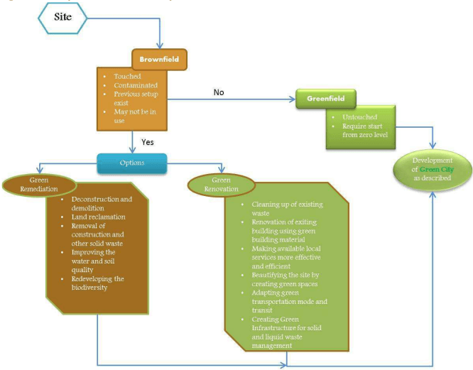
Priority shall be given to redevelopment of contaminated and dense sites, which are environmentally degraded or demographically saturated. Focus should be on green redevelopment of such site, which can improve the overall condition of existing sites. Thus, it is advisable to prefer redevelopment on brownfield sites than fresh development on a greenfield site until absolutely essential. In such a case, brownfield redevelopment makes efficient use of existing infrastructure. The process for the decision and actions is given in the figure below:
7TERI with support of MNRE
Figure 5.1: Way towards Green Redevelopment
5.4.2Compact city
Urban sprawl is a resultant of an ever-expanding city jurisdiction due to absence of compact development practices. This has resulted in undesirable extension of urban infrastructure, encroachment of valuable agricultural land, raising cost of development and also increasing carbon, water and energy footprints.
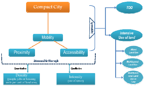
Concept of Compact City revolves around high-density development without compromising the quality of life of the people. Cities based on compact approach may or may not incorporate all dimensions of a green city approach, stated under section 5.4.1. This approach largely solves the problem of externalities such as friction on space (congestion), travel time delays and losses in economic productivity, air and water pollution, solid waste collection and disposal. The optimum density reduces the capital and operating costs of providing public infrastructure and services and improves overall accessibility.
Figure 5.2: Compact City's Concept and Approach
Source: Various sources including Fact Sheet, UNESCAP, MILUNET, Practitioner's Guide, 2006 etc.
As shown in the figure above, the efficient densification and effective intensification needs to be balanced in order to maintain the liveability of people.
5.4.2.1 Key Benefits of Compact city
The benefits of the compact city approach are:
■ Efficient use of land and urban containment
■ Increase in the number of ridership for economically viable MRTS
■ Environment protection by lowering the climatic change emissions
■ Protection of ecological diversity, countryside and land for agriculture
Efficient delivery of utility services in more densely populated areas. Due to the economies of scale in supplying energy, water and treating waste, it is less costly to deliver urban utility service in compact cities than in suburban areas 8 .
- Increased social interaction leading to safety against crime.
■ Less travelling distances that saves time, money and fuel consumption per capita.
The approach of compact city development is given overleaf:
5.4.2.2 Transit Oriented Development
Transit Oriented Development is a compact & integrated transportation development, which should be incorporated in Compact Cities. It is defined as, “any development, macro or micro that is focused around a transit node, and facilitates and complete ease of access to the transit facility, thereby inducing people to prefer to walk and use public transportation over personal modes of transport.”
TOD provides opportunities by access to high-quality public transportation by enhancing connectivity and contributing to attractive and walkable distances through
8 Fact Sheet, UNESCAP.
9 Draft UTTIPEC Guidelines, 2012.
densification. TOD Ideal land use mix and mixed land use development (with Density) and the Transit mode function at various city destinations are indicatively explained in the Table 5.3. High density, mixed-use and interconnected street networks reduce per capita vehicular trips. This can be achieved through a balanced mix of job, housing and markets along MRTS corridors.
Table 5.3Transit Oriented Development Matrix
TOD
Ideal Land use mix and mixed land use development (with Density)
Transit mode function
Core Area
Residential: High IntensityCommercial/ Office: Medium IntensityMixed UseSupporting retails & services
Bicycle LanesPedestrian NetworksIntermediate transportation supported by non-motorised vehiclesLimited Parking Lots
Commercial Zones
Employment (commercial, office, industrial, institutional): High IntensitySupporting retail & services: Medium DensityResidential: Minimal
Parking Lots, if requiredPedestrian NetworksBicycle LanesBRT and Bus StopsIntermediate transportation supported by motorised vehicles
Neighbourhood
Residential: Medium IntensityEmployment (commercial, office, industrial, institutional): Medium IntensitySupporting retails & services
Pedestrian NetworksBicycle LanesConsiderable Multi-level Parking AreasIntermediate transportation support by non-motorised vehicles
Peri-urban Area
Commercial: High Intensity along TODResidential: Medium Intensity in inner regionMixed Use including compatible institutional use
Transition to higher density and greater mix of uses close to the transit sourceBRT and Bus StopsGreen Interconnected Pedestrian NetworkConsiderable Multi-level Parking Areas
Source: Transit Oriented Development Policy Guideline, Calgary, 2004.
As a whole, TOD encourages use of non-motorized transportation, directs compact high-density developments, intensifies under-utilized urban areas through redevelopment, leads to lower infrastructure costs and increases public safety, mobility options and health benefits.
5.4.2.3 Intensive Use of land
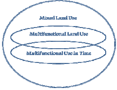
The intensive land use offers cities the possibility of (re)development of urban areas for a number of functions that, in combination, can offer residents, workers and visitors high quality services. This concept can be sub-divided into three types with combinations as shown in Figure 5.3.
Figure 5.3: Types of Intense Land Use
Source: MILUNET, Practitioner's Guide, 2006
Mixed Land Use: Mixed-use development is the practice of allowing more than one type of use in a building or set of buildings which can be a combination of residential, commercial, industrial, office, institutional or other land uses. It is presumed that mixed land uses yields socio-economic benefits and therefore has a positive effect on housing and commercial values.
Good mixed-use can be defined as a finely grained mix of primary land uses, namely a variety of housing and workplaces with housing predominant, closely integrated with all other support services, within convenient walking distance of the majority of the homes. (Murrain 1993:86). It is also referred as cellular development. Mixed use is to be carefully allowed along with the compatible use only. The mixed use of land and the dominant use thereof should be referred from Chapter 9 on Simplified Development Promotion Regulations.
The approaches for promoting mixed-use development can be by increasing intensity of land use, increasing diversity of land use or integrating segregated uses. The key parameters for integration of different uses can be:
The functional and physical integration of different uses such as Residential, Commercial – Retail & service and Public Semi Public.
- Integration of three or more significant revenue producing uses – Industrial, Commercial – Wholesale, Retail & service and Public Semi Public – offices
In an urban space, mixed use development can be planned at selected locations with ideal mix, such as a) City or town centres comprising the commercial and civic core of town and cities, b) Inner city areas and c) Peri-urban locations and greenfield sites in urban fringes as also indicated in Table 5.3.
Mixed layer development/ Multifunctional land use:
Mixed layer development is based on the principal of high intensity with vertical integration. It is under the category of multifunctional land use and also termed as "Layering Development".
Vertical integration has many benefits to offer to cities as a whole. Benefits include energy-saving potential, reduction in unnecessary journeys, improves overall
accessibility and social inclusion possibilities offered by combining housing, shopping, work, transport, recreation, culture and social functions within one area. This combination also helps to utilize the full potential of an urban site, leaving sufficient open spaces for a greener surrounding. A mixed-use high-rise development diversifies the use of space within a single building structure, which in turn saves horizontal travelling, and hence additional land requirement.
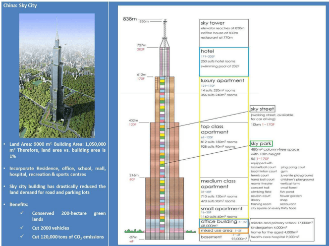
Mixed layer development provides (re)development opportunities that ease the way towards Compact Cities. This concept should be preferred for abandoned sites within the city instead of building on greenfield sites on the edge of town. Therefore, brownfield sites can be redeveloped to offer a higher building density by layering different functions on top of each other. The land use structure and densities given earlier in this chapter is not applicable for mixed layer development. Such planned areas are proposed to have high average density up to 800-1000 pph, with large open spaces and inter-block margins. Typically, this form of vertical integration land use development has commercial/retail on the street level with offices and recreational commercial on the top levels, while the intermediate levels are for residential, well developed open spaces, institutional. Case study of Sky City, China, is a world-class example, which is explained below.
Figure 5.4: Case Study of China Sky City
Source: Sky City, China.
High-rise development may limit the access of light to the lower storeys and therefore demands slender buildings or appropriate setbacks from the boundary wall. The recommendations of the Expert Advisory Committee (EAC) for high-rise buildings are:
The height of the building should be linked with the width of the road on which the proposed building is to be located;
- Also the distance of Fire Station from the building so that in case of emergency, the Fire Tender may reach in the shortest possible time.
The EAC also recommended that the provisions and the guidelines, as applicable, of the State Departments and National/State Disaster Management Authority should be strictly followed 10 .
Multi-functional use in time:
A public space or a building can have different functions at different time periods. For example use of spaces even buildings cab ne used in shifts in a day allowing different types of uses in different shifts.
School playground, which can be utilized by the students during school hours and later in evening wherever possible, can be used for sports training and practice purposes or public stadium which can be seasonally used as fair grounds. Such areas can be considered especially in small size towns where infrastructure and funds are limited.
5.4.3Smart city
A smart city uses information, communication and technology to enhance its liveability, workability and sustainability. A smart city is build-up by key basic functions: Information collection, communicating, and crunching (analysing). The two basic steps towards Smart city are:
DATA- Created by the already implemented information technology. Some of the Indian cities have created a cornucopia of data in past few decades, which can form the basis for the development of a Smart city.
DIGITAL DNA (BUILT ENVIRONMENT DATA)-Data collected by building departments, engineering departments, land department, planning department, tax department and department of postal services. India is still finding its footprints in this regard.
In view of rapid urbanisation and high congregation of population in large cities, it is imperative to make use of advances in technology, capability to make cities safer and protect cities from cyber-crime and also augment the quality of governance with higher levels of transparency and accountability. Such cities, which take advantage of advanced technology, are called as Smart Cities.
10 MoEF Office Memorandum, Guidelines for High Rise Buildings, 2012.
5.4.3.1 Important Insights
The following figure provides the important insights of Smart City application globally.
Figure 5.5: Important insights of SMART city application globally
NEED
DRIVERS
ELEMENTS
Growing urbanizationGrowing stressInadequate infrastructureGrowing economic competitionGrowing expectationGrowing environmental challengesRapidly improving technology capabilitiesProtection from Cyber CrimeRevolutionize people’s relationship with Govt.
Legal provisions and InsurancePlanning and designConstruction Commission and handoverFacility operations-Space planning, Asset Management, Maintenance, Environment Health and Safety security
Enhanced Livability-Better living conditionsEnhanced Workability-Better working conditions( broadband connectivity, clean, reliable, inexpensive energy, efficient transportationEnhanced Sustainability
Siloed, piecemeal implementationsLack of FinancingLack of ICT know-howLack of Integrated ServicesLack of citizen EngagementLack of a Smart City Vision
Installation of smart meters and sensorsSmart thermostats and Building management systemHealthcare consultation via computerInstallation of intelligent transportation management software, roadway sensors, smart parking apps.Setting up of Smart Grids
Source: Various sources including Smart Cities Readiness Guide, RICS-Smart Cities.
5.4.3.2 Universal Targets to achieve Smart city development
There are mandatory targets that must be accomplished in order to propel on the smart city path, these are termed as “Universal” as each of them applies to every city responsibility. The Check Sheet (Implementation Progress) reflects the strong and the weak points in the existing city infrastructure. Status of this matrix reflects the preparedness of the city to be a Smart city and helps in prioritizing the points on the basis of the status (progress) in order to drive on the path of development towards being a Smart city.
Figure 5.6: The Universal Targets
Enabler
Universal Targets
Implementation Progress
None
Partial
Over 50%
Complete
How Smart Cities Deploy and Use ICT
Instrumentation and control
Implement optimal instrumentation
Connectivity
Connect devices with multi-service communications
Interoperability
Adhere to open standards
Use open integration architecture and loosely coupled interfaces
Prioritize use of legacy investments
Security & Privacy
Publish Privacy Rules
Create a security framework
Implement cyber security
Data Management
Create a citywide data management, transparency and sharing policy
Computing Resource
Consider a cloud computing framework
Use an open innovation platform
Have access to a central GIS
Have aaccess to comprehensive device management
Analytics
Achieve full situational awareness
Achieve operational optimization
Achieve asset optimization
Pursue predictive analytics
Source: Smart Cities Readiness Guide.
The essential elements of focus in a Smart city include:
5.4.3.3 Smart grid concept
A smart grid is a modernized electrical grid that uses analogue or digital information and communications technology to gather and act on information, such as information about the behaviours of suppliers and consumers, in an automated fashion to improve the efficiency, reliability, economics, and sustainability of the production and distribution of electricity. Metering and Smart power generations are the two basic steps taken in the direction of handling power in cities.
a. Smart meter- Smart meters help utilities to better detect and manage outages. Smart meters coupled with advanced metering infrastructure (AMI) helps to pinpoint problems in the grid, allowing determination of faults and failures in no time 11 .
b. Smart power generator- Smart power generation is a concept of matching electricity production with demand using multiple generators, alternatively to buffer the peak and high demand for load balancing. These generators are designed on smart technologies to operate efficiently at chosen load 12 .
11 A U.S. Department of Energy study showed that real-time pricing information provided by the smart meter helped consumers reduce their electricity costs 10% on average and their peak consumption by 15%.
12 Source:GE: Smart grid technology guide.
5.4.3.4 Smart Transportation Concept
The smart transportation refers to the integration of information and communication technologies with transport infrastructure to improve economic performance, safety, mobility and time saving of the citizens. The above can be accomplished by incorporating the following technologies in the existing structure:
a. Digital view terminals-These terminals provide users with an intelligent navigation system that optimizes the best routes, alternative destinations, efficient movement by a well-informed guidance from the terminal. For example, the entire city's bus lines, their stops, and drop-off and pick-up times are displayed on the terminals along with satellite street views of locations, such as of restaurants and other tourist attractions. Coordinates for banks, schools, hospitals, and real estate are also featured for the citizens to determine best-suited route between destinations.
b. Intelligent roads- It includes setting up of sensor technologies in the pavements and over the bridges, which can be combined with the data collected from moving vehicles to provide operators, maintenance authorities and road users with rapid warning of emerging problems.
c. Traffic Prediction Tool-It predicts traffic flows over pre-set durations (10, 15, 30, 45 and 60 minutes) by stimulations. With these predictions, traffic controllers can anticipate and better manage the flow of traffic to prevent congestion and save time.
Other smart applications in the intelligent Transportation system may consist of:
■ Optimised dynamic signalling
■ Automatic parking system,
■ Advanced Driver Assistance Systems (ADAS),
■ Satellite application for emergency handling, traffic alerts, road safety and incident prevention
■ Automated transport systems.
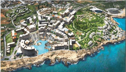
Case Study: Malta, World's first Smart Island
Malta is a group of small islands 50 miles to the south of Sicily. Smart meters are installed in the island for both electric and water customers. These smart meters records the data automatically and sends the data back to the office for billing. Smart meters also act as the analysis instrument that locate problems and determine when and whether to expand the grid. The new smart water grid has increased theft detection, and has also introduced new pricing options for customers that reward conservation.
Figure Error! No text of specified style in document..7:
Malta: World's first Smart Island
Source: Smart Cities Council-Readiness Guide.pdf
The goal of Smart City Malta is to put everything a high-tech company needs to succeed in one place, including state-of-the-art ICT infrastructure along with a host of IT, media and production services.
5.4.3.5 Application of Built Environment Data
The built environment data of the city is captured by the different departments to develop a blue print of the city and its attributes for virtual representation of the physical city. This data forms the DNA for the smart city. It includes:
■ Demographic distribution
- Land uses
■ Transportation and other infrastructure framework
■ Forests and parks
■ General urban plan
- Space and organization plan This data when linked with the Information communication and technology develops the digital DNA, which forms the basis for the Smart city. The software and service layers for the built environment data can contain the following layers13:
Data layer: that presents all the information, which is required, produced and collected in the smart city.
13 Source: Urban Planning and Smart Cities: Interrelations and Reciprocities, Leonidas G. Anthopoulos.
■ Service layer: This incorporates all the particular e-services being offered by the smart city.
Infrastructure layer: that contains network, information systems and other facilities, which contribute to e-Service deployment.
User layer: that concerns all e-service end-users and the stakeholders of a smart city for dialoguing and in decision-making. The participation includes:
- The local stakeholders – who supervise the smart city, and design
- Those who offer e-services- and
- The end-users -who "consume" the smart city's services
5.4.3.6 Urban planning and smart city interrelations
On the attributes discussed in the preceding section, various e-service portfolios can be offered in a modern smart city, some of which have been mentioned below:
Table 5.4e-Services of a Smart city
e-Services
e-Government
Public complaints, showing administrative procedure, bringing transparency in governance.
e-democracy
Performing dialogue, consultation, polling and voting of issues of city.
e-Business
Supports business installation.
e-health and Tele-care
Distant support and services to elderly, civilians with diseases, disabled
e-learning
Distant learning opportunities, training material to the students.
e-Security
Supports public safety via amber-alert notifications, school monitoring and natural hazard management
Environmental services
Information about recycling, guide households and enterprises in waste/energy/water management
Intelligent Transportation
Offers tools for traffic monitoring, measurement and optimization.
Communication services
Broadband connectivity, digital TV
Source: Compiled from Urban Planning & Smart Cities: Interrelations and Reciprocities, Leonidas G. Anthopoulos.
5.5City Typology
Urbanisation over centuries and evolving city morphology has given shape to the present day cities in India. Most post-independence cities have emerged from planned directions and yet have experienced population explosion. Cities also have benefited from planning based on Government schemes and programmes. However, the functions of the urban centres have taken natural course to its maturity, without or with intended interventions. These are the consequences of response of human settlement and interaction of societies. Focus on planning even application of land use standards and development controls could vary depending upon the typology of the cities.
Situation of the city: Situation of the city is the prime factor to be considered while planning. City situation is established on its growth in size, physical configuration or route pattern and largely with its function. Cities, besides multi-functional, can be also defined on the basis of the prime economic activity and/or evolution of the city. Such cities with typical location, situation and functions need focused approach while planning, to address the associated issues. Some of such kinds are:
■ Hill cities,
■ Inner cities/ walled cities,
■ Industrial cities,
Religious cities,
■ Tourism cities,
■ Heritage cities,
■ Port cities,
■ Medi-cities (townships),
■ Sports cities (townships)
Site and situation specific solutions: These cities, owning to its nature of development and population, and either permanent, new settlers or floating population, have specific functions and therefore have associated issues. Some of the generic ones are:
- Lack of alternative economic activities,
■ Stagnation of city growth,
■ Strict segregation of classes by profession and income,
■ High crime rate,
- Lack of public spaces,
- Lack of recreational activities,
- Lack of educational facilities for low income class/ poor,
■ Significant ratio of bachelor population,
- Lack of gender specific health facilities and other facilities,
■ Investment oriented land/property ownership,
- Others: pressure on public utilities, lack of social guidance in case of exposure to cultural variation etc.
Such as, in case of industrial cities or township, specific drawbacks are observed like lack of recreational activities, lack of alternative economic opportunities, and social activities. These townships are limited to work - home relationship and lack recreational activities and therefore, there is a need to focus on providing dedicated public spaces for population to interact in such cities/towns.
Similarly, other city typologies also have specific issues to be addressed for which approach can be defined while preparing plans. Mix of economic activities such as service industries and social activities should be promoted to encourage the avenues for wholesome development.
Increased rate of crime as observed in some industrial and port town is primarily due to segregation of population income classes, lack of recreational activities, lack of educational facilities for low income class, and to some extent due to high proportion male workers living without families and also large number of bachelor population.
Therefore to promote sustainability of cities, its situation in terms of its function and its social behaviour shall be addressed. Such cases need emphasis on complimentary requirements of the city, besides its prime economic activity and physical infrastructure for holistic development of the city. Some of the complementary activities are suggested below-
■ Promotion of service industries,
■ Educational facilities with emphasis on technical institutes
- TOD mix of institutional and administrative land use,
■ Social infrastructure, targeting needs of specific strata of population
■ Recreational facilities, also theme based facilities
■ Heritage and religious activities to be promoted for mixing of economic base and population
- Earmarked spaces for the urban poor / informal sector residents or their activities14.
5.5.1Hill city
The National Building Code defines hilly areas as “Any area above 600 m in height from mean sea level, or any area with average slope of 30∘ , considering the sensitive and fragile eco-system of hills and mountains.” However, the State Governments may identify and notify areas to be covered under ‘Hilly Area’, which need to be dealt with special consideration, when developmental activities are taking up.
Hilly areas have fragile ecosystems, which need to be conserved. Therefore planning and development strategies for hilly areas shall have to be designed with added sensitivity and sound land use planning and settlement planning.
5.5.1.1 Associated Issues
Hilly areas have a sensitive ecosystem consisting of mountains, rivers and valleys, several lineaments and some of them even experience extreme weather conditions. These varied natural features also make hilly areas a suitable place for tourist destination, thus creating a pull for commercial development and urbanisation. Also, many rivers originate from the Northern Himalayan range, thus the areas attract development of hydro power plants, which directly or indirectly have shown great impact on the river hydrology and bio-diversity.
The common issues associated with planning in Hilly areas are:
Hilly areas in Himalayas and Northeast experience heavy rainfall, which makes the shallow soil, cover highly susceptible to erosion (such as in Darjeeling)15. These conditions necessitate conserving the precious soil cover during monsoons and harvesting irrigation water for dry months. In other areas heavy rainfall causes deep weathering of sedimentary rock and rapid and active erosion of weathered materials from steep slopes.
- There are issues with respect to mobility and connectivity due to steep slopes and difficult terrain.
Also geographically younger hill areas with high seismic activities make settlements vulnerable to disaster risks. In such areas regulating construction activity is of prime importance in planning.
In hilly areas, remarkable variations in culture and practices(including in many places tribal culture and rich craft skill) exists between the settlements even within short distances as compared to those in plain areas 16
As terrain plays a crucial role in the hilly areas, settlements are to be on definite habitable lands only and thus, its carrying capacity needs to be determined for adequate planning.
The planning status of hilly areas, in the present state, is uncontrolled creating haphazard growth due to need for urbanisation, industrialisation (such as quarrying and hydro power generation) and intrusion of commercial activities (such as tourism industry) on the limited land cover, typically along
14 Also Suggested in ‘Strategy paper on master plan formulation, inclusive planning, prioritization for housing and pedestrian movement, 2010’
15 Planning Commission Report of Task Group on Problems in Hilly habitations.
16 Report of the Evaluation Study on Hill area Development programme in Assam and West Bengal", Planning Commission, June 2010.
hill routes. These trends has led to encroachment on forest land and precious green cover, construction on unsuitable lands and development at higher level of ridges, thereby disturbing the natural ecosystem and making the areas more vulnerable to disasters.
- The impacts on infrastructure are - traffic chaos, inefficient service infrastructure and congestion in prime locations, inadequate social infrastructure.
- The impacts on the environment are loss of hill and forests, degradation of stream system, landslide and erosion, increase in natural hazard as earthquake, landslide and manmade hazards such as air pollution and roadway noise.
5.5.1.2 Strategies for Development
Hilly areas have various factors, which necessitate a thrust on adoption of an integrated planning approach for conservation, preservation and planned development.
Strategy 1: Land Conservation and Optimisation:
Environment Inventory/ Impact Assessment: For planning of the new settlements or working out the strategies for the growth of the existing settlements, it is necessary to conduct detailed environmental inventory/ impact assessment. The inventory would involve geological investigations, slope analysis, soil, flora and fauna analysis, climatic inventories, vulnerability to natural disasters (such as earthquakes, landslides, floods etc.), etc. In addition to this the aesthetic factors, cultural, architectural and historical heritage, scenic/ landscape value shall also be taken into consideration.
Identification of Developable Area: Identification of developed area is calculated by deducting the natural ecological area from the entire township jurisdiction. Jurisdiction may be large to control the surrounding areas. The classification of land uses should be given only for developed area, while the rest of the ecological area shall be for conservation or restoration.
Hill Town Developable Area = Hill town jurisdiction area - Natural Ecological Area.
Land use optimisation: Keeping in view the scarcity of good buildable land and also the high cost of the construction, it is necessary to optimize the use of land by calculation of carrying capacity and land suitability analysis. Green building approach should be adopted such as use of cost effective and appropriate building materials and technologies.
Strategy 2: Sustainable development based on Watershed Management:
A watershed, also called a drainage basin or catchment area, is defined as an area in which all water flowing into it goes to a common outlet. People and livestock are the integral part of watershed and their activities affect the productive status of watersheds and vice versa. From the hydrological point of view, the different phases of hydrological cycle in a watershed are dependent on the various natural features and human activities. In hilly areas or where intensive agriculture development is planned, the size of watershed relatively preferred is small. 17 Watershed managements, i.e. river basin management also is important in the context of regional planning both in terms of as a source of water and sources of disaster risk like flood etc.
During the Tenth Five Year Plan of Government of India, emphasis was on watershed development and ecological restoration/preservation for the hill areas of Assam and West Bengal. In the sixth Five Year
Plan, the Planning Commission had suggested achieving a balance between beneficiary-oriented and infrastructural development programmes, keeping in view the vital importance of ecological restoration and conservation. This can be achieved through 18 :
■ Better water and land-use and control of soil erosion through watershed management,
- Afforestation, silvi-pasture development and replacement of annual crops with perennial shrubs and trees and plantation crops in steep slopes and development of other high value-low volume crops linked with processing and marketing.
- Rural and small industries and electronic and precision instruments industries can also be promoted taking advantage of favourable weather conditions.
To understand watershed system data from latest and authentic sources to be collected (details provided in Chapter 7), simulation models may be used to analyse (drainage pattern modification) scenarios before Development Plan Preparation and building regulations.
5.5.1.3 Proposed Land use Structure of Hill Towns
The proposed land use structure for hill towns are:
Table 5.5Land use structure for hill towns
Land use Category
Percentage of Developed Area
Small
Medium
Large & Metropolitan Cities
Residential
50-55
48-52
45-48
Commercial
2-3
2-3
4-5
Industrial
3-4
4-5
4-6
Pub. & Semi Public
8-10
8-10
12-14
Recreational
15-18
15-18
16-18
Transport & Communication
5-6
5-6
6-8
Ecological
Balance
Balance
Balance
Source: UDPFI Guidelines, 1996.
The ecological area (non-developable area) given in the table above for Hill towns is applicable for the hill town jurisdiction developable area only. Hill town developable area shall be considered as area hill town jurisdiction minus natural ecological area. Where, non-developable area is defined as - Earthquake/landslide prone, cliffs and environmentally hazardous area, areas adjacent to fault lines, areas with slope higher than 45∘ , flood plain and areas adjacent to major drainage lines for general guidance and all environmentally sensitive areas. Land suitability analysis should be an important tool in first principal approach for deciding on land use proportions.
5.5.1.4 Aspects of planning {19}
The important aspects to be considered in planning for the hilly areas are suggested as below:
The hillside with less than 30∘ slope are in general stable. Therefore, building sites (temporary or permanent) should in general be located on hillside with not more than 30∘−45∘ slope. In areas where
most of the land is above 30∘ degree slope, spatial regulations should control construction activity on slopes above 30∘ degree with maximum of 45∘ provided that appropriate technology is used.
The maximum height of the building to be fixed, such as in States of Meghalaya maximum building height permitted is 15 meters on hills.
Flat land is normally not available in hilly regions. The houses are required to be constructed on partially sloping land made available by cut and fill. It shall be necessary to protect the house by building retaining walls/breast walls to avoid landslides occurring at time of earthquakes or heavy rains.
Cut slopes with height less than 5 m or two to three storey heights of residential buildings are in general stable. For higher cut slopes special investigation should be carried out and details of protection works should be worked out and implemented.
Site development in hilly regions consumes about 30 to 40 per cent of total cost of building complex, therefore the following investigations shall be done to obtain the following geotechnical parameters:
a. Type of Soil Rock: Weathered or intact, dip of bedding planes, drainage conditions, shear planes, material between the joints, tension cracks, type of plantation, verticality of trunks of the trees etc. Cliff sides and spur faces need to be protected with appropriate technology including where netting with tables and/or blowing of RCC along the walls.
b. Thickness of overburden, nature of soil strata, details of soil matrix etc.
c. Estimation of shear-parameters of the in situ soil mass, which will govern the failure.
d. Drainage pattern of the area and permeability tests in the area to see the Drainage conditions.
e. Specific slip zones in the area, if any.
Roads and paths: Street orientation shall preferably be East-West to allow for maximum South sun to enter the buildings. The street shall be wide enough to ensure that the buildings on one side do not shade those on the other side. Hill Road Manual (IRC: SP: 48-1998) should be referred to for detailed guidelines for planning roads in Hilly Areas.
Provisions for Landslide Hazard Mitigation, Seismic Micro-zonation and mitigation of Liquefaction hazard should be integrated.
Specific aspects for New Hill Towns:
The new hill towns will have to follow the basic principles of hill architecture including use of local building materials, slanting roofs, seismic bands in structures etc. so that they merge in cultural landscape of their regions.
Travelling time from nearest town to the new township should be at least one hour or 20 Km.
The new town should be self-sufficient in infrastructure and its area should ideally not be less than 40 hectares.
Provision of facilities for additional (and /or floating) population should be made.
Specific aspects for Buildings in Hilly area:
A minimum clearance of 1.5m should be provided between toe of boundary wall and building wall.
On the uphill side of the building on a sloping site, the natural flow of the water shall be diverted away from the foundations.
The slope of ground all around building should be not less than 1: 50 built in such a way that rain water does not find way to ingress in ground excessively and moves away quickly to surface drains or away on adjoining hill surface towards natural streams.
A minimum of 0.75 m wide apron should be provided all around the building to prevent entry of water into foundation.
Stepped terrace development and stepped storeyed building construction may be adopted for offices, schools and other building complexes 20 because of following advantages:
a. It results in least hill cutting, disturbance to hill stability and also in least deforestation.
20 (Refer conditions of development from IS 14243 Part 2: 1995 for details )
b. Cost of site development works, slope protection and other protection works is reduced considerably.
c. Least load comes on valley side, so danger of foundation failures is avoided.
Buildings to be provided with good drainage facilities to prevent excessive saturation of sub surface formations. Construction should not obstruct existing surface drainage courses.
Buildings shall be located on the south slope of a hill or mountain for better exposure to solar radiation. At the same time, locating the building on the leeward side may minimize exposure to cold winds.
Appropriate solar passive methods, such as orientation, double-glazing, trombe walls and solar collectors, to be adopted to achieve climatic comfort with little use of conventional energy.
5.5.2Planning for Inner city
Walled cities, old city, often central zones, which are also generally the core area of the settlements, are referred as inner cities. These city parts have been the melting pot for cultures with a history. Some of the old cities have been historically an important trading centre, owing to its regional prominence, strategic location and trade links. However, owing to its prosperity, some of the cities were under the threat of plunder and loot, which reshaped the city form over the centuries (as also walled cities). These cities are marked by key features, such as, narrow roads (gullies), dense built-up, often mixed use of land, small plot sizes occupying 100% ground for built-up, social homogeneity, limited public spaces, which are usually congested developments, in comparison to the modern day cities.
5.5.2.1 Associated Issues
Common issues associated with the inner cities:
■ Out migration of local residents and release of residential spaces for commercial use,
- Dilapidated buildings (as building owners only repair their buildings, while little or no reconstruction is takes place) and vacant properties,
- Narrow roads- not planned for vehicular movement,
■ Unorganized on-street parking at various locations,
- No prominent public transport system present in the city,
■ Presence of cottage or household industries and polluting industries
- Prominence of on-street encroachments for informal markets & hawkers,
Due to shift from residential to commercial land use, emergence of warehouses, go-downs, workshops or other non-compatible activities,
- Old water supply distribution network and in non-metric sizes, difficult to maintain,
■ Repeated excavation of roads damaging the underground utilities and disturbed road levels,
Overall lack of social infrastructure facilities compared to the density of the inner cities
- Outcrop of Slum like conditions in the open areas surrounding historical properties or on old recreational open spaces
5.5.2.2 Alternative strategies for the Redevelopment and Regeneration
Redevelopment and regeneration are the prime planning aspects of inner cities. The space norms and development control rules that are generally applicable to other city areas are normally not applicable to inner cities. The two alternatives for the
redevelopment of an inner city/ old city are based on the strategy of revival or in-situ development. These are:
Alternative 1- Modification in Built-up: In this approach, the residential built up is adjusted with the plot size and height from urban renewal point of view. The building density is redefined, usually by increasing the permissible FAR/FSI as permissible by the available infrastructure. It allows the market forces to reconstruct and redevelop the core city areas. The urban local authority may provide supporting infrastructure through betterment levy or charges. This tool of redevelopment is in practise in major cities like, Hyderabad and in some parts of the old Delhi (Shahajahanabad). Abutting road width, plot sizes, accessibility and land use regulates the increased building height. This entails amalgamation of plots.
This alternative can be applied for the entire inner city or it could be limited to an identified area such as along the transport corridors as in the case of Old Delhi (Shahajahanabad) wherein a 500 meter influence zone of metro rail is permitted with a suitable enhanced FAR. 21
An added advantage of this alternative is amalgamation of residential units. To improve the morphology of the core city, increase in unit size of the residential plots is also often necessary, especially where very small units are present. Higher FSI, for medium size plots, even marginally will lead to amalgamation of small and very small plots by market forces. This will improve the urban design and density of residential areas. However amalgamation of plots is to be carried out in lines with regulations, which is to be defined based on the study of the area by the local authority. The redevelopment project of east Kidwai Nagar, New Delhi is among the first initiatives as a vision project of Ministry of Urban Development.
Alternative 2- In-situ Development: In order to conserve the characteristics of the inner city, this alternative is adopted to maintain and revive the old city by different mechanisms. Unlike the alternative 1, in-situ development maintains the height and the building foot print, by carefully using Transferable Development Rights (TDR). This alternative is used where the redevelopment strategy is to maintain and encourage the heritage of the city and its housing morphology, as in the case of Ahmedabad, where Tradable Development Rights are provided for the notified Structures, Buildings and Precincts in the form of Tradable Right Certificate by competent authority. However the authority controls other activities such as:
- The Permissible Uses for the Heritage Areas and other buildings on the basis of its plot size and floor.
■ Amalgamation and/or Sub-division not be permitted in the Zone,
- The owners of these heritage structures and buildings are required to conserve the following original aspects of their Buildings:
- All Façades
- Building Footprint
- Character of Open Spaces such as courtyards, khadki, streets, etc.
The in-situ development also does not encourage road widening until necessary, as it aims to preserve the building façade. Therefore parking spaces are created through community initiatives and by consultative process. In case if it is not feasible to provide the required parking within the existing building as per Regulations, the Competent Authority may recover fees for deficit parking to develop on-street parking/parking lots/parking structures as a part of Parking Management Plan.
The concept of Accommodation Reservation may be introduced for social infrastructure whereby for the provision of essential public facilities to be handed over to the local body / government, the owner of
21 Source: ITPI article by A.K. Jain, Commissioner (Planning), Delhi Development Authority.
property is given full permissible FAR on the component of public facility. Vacant properties should be preferred for this purpose.
The two alternatives of redevelopment to be chosen carefully and a combination of the two may be used for suitable sub-zones in an inner city. However the redevelopment strategy is to cover the key aspect i.e. positive growth for the city to be a liveable area and also as a work space. Therefore in most of the Indian inner cities, mixed land use is to be recognised as permissible and thereafter organised, as the city is planned on the concept of work & live with inherited benefit of reduced travel trips. The land use structure given in Table 5.2 could be modified and adjusted for mixed land use as planned by the local authority. To achieve this, regeneration is to be a part of the redevelopment, including socio-economic development, maintaining and encouraging commercial lifeline of the inner city for its revival.
5.5.2.3 Aspects of Revival
While planning, planners face the problems associated with road levels, lying of new pipelines, parking in residential areas, decongestion, fire safety issues, requirement of road widening and lose of heritage façade, provision of land for social infrastructure and sometimes re-planning underground infrastructure. Core city revival is based on conservation, promotion and solution. These can be:
Out-Shifting of polluting, noxious and hazardous trades / industries and de-limitation of non-residential non-compatible activity with priority,
To decongest the inner city, proposal can be to develop counter centres in the form of Integrated Freight Complexes at the peripheral location or new industrial area,
Iconic developments along the historically valuable areas and if space allows - encourage city level recreational areas to create a pull factor towards the old city,
A new set of development controls for Mixed Use, enhanced FAR and TDR applicability. Mixed use to be maintained with regulations on the road width, plot sizes and density,
Conservation and restoration of historical buildings. Provisions for FAR and Tax incentives for those who have to maintain the architectural controls,
Revival of cities by alternative public transport system technically modified for the road network and as per the trip generation,
For parking, multi-level parking is one of the solutions for identified residential pedestrian,
In case of new development or redevelopment, stilt parking to be mandatory,
Adding street furniture can enhance street design. This is to facilitate public space for community interaction and promote pedestrian movement,
In congested and bottle neck areas, solutions such as one ways and multi-level parking to be adopted,
Alternative solutions of use of smaller fire hydrants for very narrow roads for the fire safety,
To meet the social infrastructure requirement, reducing space norms up to 50-60% in case of space non-availability in the core city. In order to compensate for the shortfall in various types and levels of facilities in the existing built-up area, such facilities may be provided in contiguous / proximity to sectors of new development.
Multi-functional uses should be proposed to encourage optimum utilisation of existing built-up infrastructure.
ULBs to initiate developing database of the buildings, with attributes such as its age, height, heritage value, revenue collection and other points as desirable.
5.5.3Industrial city
Cities with major thrust in manufacturing and production are industrial cities. Such a focus on manufacturing was initially in the beginning five year plans after
independence, when the focus was on heavy iron and steel manufacturing. Industrialisation again boosted after liberalisation in 1991 and encouraged developing clusters for export in 2005 by the SEZ Act, 2005, which provides for the establishment, development and management of the Special Economic Zones for the promotion of exports. There were also schemes proposed for promotion of cluster/ park development by respective Ministries, while Small Scale Industry (SSI) was defined under Micro, Small & Medium Enterprises (MSMED) Act, 2006.
Lately, Government of India has also announced the National Manufacturing Policy in year 2011 with the objective to enhance the share of manufacturing in GDP and increasing employment. Under the National Manufacturing Policy, the New Investment and Manufacturing Zones (NIMZ) guidelines was cleared by the Cabinet in 2011.
5.5.3.1 Associated issues
The following are the key concerns for industrial area planning:
Industrial cities are marked by high intensity of noise levels and air pollution levels, which makes unsuitable for residential. Also, improper discharges of liquid and solid industrial waste/effluents are concerns for health. These hazard prone activities have a direct impact on residential areas,
■ Movement of heavy traffic for transportation of raw material and finished goods, large share of the traffic load on the roads (highways) & rail,
- Lack of supporting infrastructure such as logistics, warehousing,
- Industries face power problems with respect to unscheduled cuts, which affects the productivity, especially in the continuous process plants. In order to make up for production loss, industries have to operate DG sets which eventually increase the overall production cost and air pollution,
- Lack of emergency facilities for fire safety and accidents, including medical infrastructure and health care,
■ Absence of integration with research and development and ICT infrastructure in Indian industrial cities,
■ Unplanned infrastructure provisions for various utilities, both underground and on surface,
- Limited space for industrial plots, allowing no expansion in future,
Other issues associated with industrial township are:
■ Issues of compatibility between processing and non-processing areas,
- Lack of alternative economic activities leading to stagnation of city growth,
- Some of the industrial towns also show high rate of crime. This is primarily due to segregation of classes, lack of recreational activities, lack of educational facilities for labour class, and to some extent due to a portion of the population is bachelor,
- Ignorance on the public transportation in the industrial areas for labour and managerial labour,
- Lack of housing for construction labour, who continue to live within and adjacent to the industrial cities for years and lack of housing requirements for low income labour and informal employment.
5.5.3.2 Planning strategies
Site location of the industrial city is the prime aspect of its planning. The siting criteria shall satisfy the environmental requirements mentioned by Ministry of Environment and Forest, which is with sufficient buffers, distance from a large size town and agricultural land (refer Chapter 6 for specifics).
Land suitability analysis to be done for identifying zones for placing hazardous industrial (uses including air polluting units and wind directions), other manufacturing industrial, compatible uses along surface water bodies, hamlets and settlements and placing of non-processing areas. For locating
industrial zone, preference to areas with easy connectivity, provision for logistics and areas with existing industries to be given, also wind directions to be considered.
Zoning for processing and non-processing areas is recommended in the ratio of 40:60 (especially in SEZ). The land use regulations have to keep in view the requirements of both these areas according to the activities envisaged. Due to the health concerns and safeguards, provision of green buffers of minimum of 500 meters between compatible and non-compatible shall be well defined while zoning(as given in Chapter 6).
Processing area: may be comprise of the following activities:
■ Industries / manufacturing;
Ancillary & MSMEs;
■ Retail Trade and commerce;
■ Go-downs and warehousing;
■ Utility corridor;
■ Port and port related activities;
■ Airport and related uses, rail, road and inland waterway and spaces for parking etc.;
■ Public utilities and any other essential services;
- Incidental and other activities for safety and security; and essential residential for the same;
■ Governmental use / activities to manage the proper functioning of such processing areas.
■ Information Technology and Enabled Services;
Within the processing areas, space for informal commercial, service industries and parking as per industrial requirement to be paid attention. For development of various types of parks – like IT parks, Plastic parks, Bio-technology parks, Food parks, Agro park, etc. the policy and norms issued by respective departments and guidelines available to be considered for planning. In absence of such handholding provisions, case studies of the specific industrial sector to be referred.
Cluster development: A cluster approach may be taken to optimise use or resources and minimise cost of production. For example, all work related to computers, IT, Communication can be housed in a cluster at the outskirts of processing area to minimise heavy transportation with in the city. Small clusters related to IT and communication can also be accommodated with in the non-processing area at uniform distance for easy reach of availability of all services in time.
Non-processing areas: Areas other than processing area are to be planned for various uses and activities, mainly as an industrial township including residential, commercial, recreational and activities related to social infrastructure like education, health care, and socio-cultural facilities.
Social infrastructure: The overall quantum of social infrastructure to be provided in the industrial township may be divided into two levels of facilities, including - Industrial city level Facilities and Local Level Facilities.
Land use: An industrial township should provide for a judicious mix of land uses / activities in such a way that it is not dependant on the neighbouring or other city. The norms and standards for distribution of land use may be as under 22 .
5.5.3.3 Proposed Land use Structure of Industrial towns
Table 5.6Land use structure for Industrial towns ^{23}
Sl. No.
Land use Category
Percentage of Developable Area
1
Residential
20-25
2
Commercial
3-4
3
Industrial
30-35
4
Public and Semi-Public
6 -8
22 Draft SEZ Guidelines study by TCPO presented to the Parliament Standing Committee. 23 Ibid.
Sl. No.
Land use Category
Percentage of Developable Area
5
Recreational
12-15
6
Transport and Communication (including logistics)
10-12
7
Water bodies & Special areas
Balance
Total
100
Note: The above landuse distribution is indicative, and may vary as per the size of SEZ, industrial town, cluster development.
5.5.3.4 Aspects of planning
The industrial town should primarily be a modern state-of-the-art township having world-class infrastructure 24 , high quality living, working and entertainment provisions, which are particularly suited to the flexible uses and space demands of modern technology and knowledge based activities.
Infrastructure:
a. All industries to be responsible for treating the effluent generated as per the CPCB regulations, for small and medium size industries infrastructure of Common Effluent Treatment Plants (CETP) to be planned. Special care to be taken in cases where the effluent after treatment is discharged into a water body.
b. Solid waste disposal to be as per CPCB/SPCB regulation, specifically for hazardous waste disposal,
c. To meet the power supply pressure, alternative source of energy to be explored in the site and situation to meet the domestic and commercial demand within the region.
d. Logistics and Parking requirement of industrial area as per the industrial area demand. The transportation infrastructure, including RoW and speed design to be as per the norms given in the transportation section of this guideline.
e. To ensure safety from high-tension power line, reduce disruption and for increasing life, infrastructure lines are to be well designed within the Row for infrastructure corridors, by allocating Right of Use as per regulations of each facility.
Non-processing areas:
a. To bring harmony in the society, integration of residential sectors (informal/low income group/managerial staff/ pockets of high income group) shall be planned to reduce friction and encourage interaction socially and economically. The locations of low income group to be in proximity to the industrial and commercial areas to facilitate easy movement and reduce pressure on public transportation.
a. Public transportation shall primarily target integration of residential areas with industrial zone.
b. In case of greenfield industrial sites, for the expansion of existing hamlets and small settlement, a buffer to be governed by respective authority (to be marked on the development plan after calculating the induced growth rate). Such buffers shall be established for recreational, livestock support and social infrastructure for the developments of the hamlets. Similarly buffers along rivers in the industrial areas shall be well protected from any water pollution by allowing river front developments with recreational activities but without permanent developments.
Space norms:
After liberalisation in 1991, several changes have taken place in the manufacturing and service industries. Among which the key shift is from labour intensive to capital intensive. Hence the space for industrial allocation is shrinking, while in service sector the work space norms are altering with the FDI in IT/BPO
24 “World class infrastructure” would consist of 24X7 hour water supply, uninterrupted power supply, efficient and pollution-free transport and modern solid waste management, sewerage treatment and communication systems.
sector. Workers space norms are to be proposed based on the latest technologies used, scale of development and investment planned. The work force ratio is as given below 25 :
Work force participation can be considered more than 75% of the total population in industrial towns, in case the Work Force Participation Rate (WFPR) is not available.
The Industrial workers density can be: 100 pph to 125 pph
The ratio of employment to land allocation should be case to case specifically for the sector of investment. With the advancing technology, the investment intensive developments will be altering the employment and space ratio.
Safeguards:
a. Disaster management Plan for the industrial towns to be prepared at initial stages of planning and integrated with the Development Plan. In case of hazardous industrial, an evaluation plan shall be designed within the transportation network, to ensure evaluation by high speed designed roads.
b. Health care facilities and emergency services to be decentralised and located in the processing and non-processing areas both.
c. Specifically fire stations to be located on the corner plot giving direct access to sub-arterial roads.
d. Local water holes and rainwater harvesting tanks to be linked with pressured hoses as a back-up to fire extinguisher.
5.5.4Heritage/ Religious/ Tourism city
Heritage areas and cities with historical and tangible / intangible cultural values; preserved, conserved and evolved by social interactions and changing economic factors have given shape to tourism in these cities. The World Heritage Organisation, Ministry of Culture, Ministry of Tourism have laid focus on the conservation, restoration and promotion of cultural heritage. Among these historical cities, pilgrim destinations and centres of religious values have emerged with broad base economic activity of tourism. Close observation of these cities revels that these cities were not designed for large population influx. Many of the religious towns with pilgrim destination in India are located on the fronts of water bodies or in the fragile ecosystems, (such as in the Himalayan ranges) where the balance between human activities and the nature is sensitive issue. It is crucial to include the eco-sensitive area mapping, evaluation of carrying capacity (refer Chapter 7 for details) and provision of eco-tourism in planning for such towns.
Planned tourism is a major contributor to cities' economy. Tourism sector provides a high multiplier in employment generation. Tourist cities' economy may almost be totally based on tourism.
As evolved from the Tourism 2020 Vision, UNWTO 2002, ‘cities or places of high population density where trips are taken by travellers for leisure and recreation can be referred as tourism cities’. Besides, the heritage and religious cities, as mentioned before, tourism cities/regions have developed from natural tourism, sports tourism, adventure tourism, rural tourism, and wellness tourism, among others. The National Tourism Policy, 2002, Ministry of Tourism rests on the principle of:
25 Source: Based on UDPFI Guidelines, 1996
- Institutional framework may be based on participation between Government and the private sector. Government to provide legislative framework to regulate tourism trade and private sector to tourism related activities,
The deep rooted relationship of tourism and culture to be realised, and promotion of cultural tourism should be encouraged focusing culture related (craft, art, performing art, living style as) saleable products for tourist.
- Greater emphasis on Eco-tourism, focusing on natural landscapes and other environmental features and also virgin traditional rural environment etc.
- Special thrust may be imparted to rural tourism and tourism in small settlements, where sizable assets of our cultural and natural wealth exist.
Linking heritage, build and nature with tourism is important. Heritage sites both global (world heritage sites) and natural are to be identified and protected. Such areas should be integrated with rest of the development based on rules and regulations specified by World Heritage Centre, Archaeological Survey of India and State Governments. Protection of sites of historical value other than officially designated at local area level may be identified and integrated in the Regional/ Development / LAPs.
5.5.4.1Associated issue
Some of the issues associated with heritage cities, religious cities and cities of tourism potential are:
■ Influx of the floating population or tourists,
■ Assessment of areas of influence of tourism/ pilgrimage,
■ Pressure on fragile/sensitive tourism zones and on eco-tourism sites in the tourist circuits,
■ Seasonal variation of the local economic base,
Unclear infrastructure estimations & planning estimations for the tourism towns due to fluctuation in the population to be served,
■ Transport planning issues associated with terrain, slopes and undulated systems,
■ Conservation and improvement of land profile, areas of scenic value and utilization of site features for strengthening the ambience,
- Issues in solid waste management especially in religious/pilgrim towns,
■ Street vending activities in the popular religious and tourist sites and measures for their rehabilitation,
- Lack of documentation of heritage buildings and areas and application of general architectural control in historical areas,
■ Supporting investment in heritage assets and generating returns by ULBs or by private sector,
- Lack of social guidance in case of exposure to cultural variation, specifically in international tourism destination, et al.
5.5.4.2Planning Strategy
A tourism city planning strategy is to be broadly based on the understanding -
For ‘Nature’ in its many forms, its mountains, streams, sylvan surroundings;
Its ‘Culture’ as manifest in the art, architecture, temples and pilgrim towns;
Its 'History' as seen in the archaeology of the tangible and intangible outputs of an earlier era.
On 10th November 2011, UNESCO's General Conference adopted the new recommendation on the Historic Urban Landscape by acclamation, as an additional tool to integrate policies and practices of conservation of the built environment into the wider goals of urban development in respect of the inherited values and traditions of different cultural contexts. The UNESCO General Conference recommended its Member
States to take the appropriate steps to facilitate its implementation and further recommended that Member States and relevant local authorities identify within their specific contexts the critical steps to implement the Historic Urban Landscape approach, which may include the following:
To undertake comprehensive surveys and mapping of the city's natural, cultural and human resources;
- To reach consensus using participatory planning and stakeholder consultations on what values to protect for transmission to future generations and to determine the attributes that carry these values;
To assess vulnerability of these attributes to socio-economic stresses and impacts of climate change;
To integrate urban heritage values and their vulnerability status into a wider framework of city development, which shall provide indications of areas of heritage sensitivity that require careful attention to planning, design and implementation of development projects;
- To prioritize actions for conservation and development;
To establish the appropriate partnerships and local management frameworks for each of the identified projects for conservation and development, as well as to develop mechanisms for the coordination of the various activities between different actors, both public and private.
Through adopted strategies, such as of UNESCO's new Recommendation on the Historic Urban Landscape, the local conservation approach is to be defined by the local authority in lines with the broader prevailing policies in India. However application of conservation, preservation and promotion is not to be equally treated. With detailed mapping, documentation and analysis, zones of treatment and extend of tourism may be identified for sustainable development. Figure 5.8 explains the integrated approach to tourism city/region planning.
High Value zone: The core zone of heritage, religious or of tourism value is the high value zone. This may consist of Natural Heritage or Built Heritage or both. Ethnic value of the zone is of the highest level and is meant for preservation. The carrying capacity of this value zone is the key to the tourism potential of the city.
Figure 5.8: Integrated approach to Tourism City/Region Planning
Native's Zone: This can be called as the residential zone of the locals or the settlement. This zone usually overlaps with the high value zone, as mentioned earlier, due to social interactions and economic relationships. The economic benefits of tourism are measurable in the native zone and improvement in the quality of life of the local population can be achieved through planned development. This zone is for conservation of the culture, valuable architecture, and for promotion of local economy. This zone is
suggested for innovative strategies to provide the city with a consistent image and therefore provide significant revenue and added value to its residents.
New infrastructure zone: The city periphery or outer zone is the new development zone. This outer zone is for the new development to come-up to meet the tourism requirements for the promotion of tourism and for city growth. By understanding market trends through market analysis, demand and needs of the tourist is to be assessed for the Tourism Product Development 26 such as experiential-shopping, festivals, emotional-cultural and historic resources, hospitality, physical-infrastructure, natural resources, restaurants, accommodation. In doing so, tourist attraction spots and areas should be first made easily accessible. Depending on the quality of such tourist area, certain experience based tourist trails can be planned with adequate support of logistics. These new developments should be integrated with the inner two zones.
The investment in this zone can draw from the various tourism infrastructure development schemes by the State. Promotion of tourism as an economic activity, alternative economic base including thrust in institutional & commercial developments is to be adopted in this zone & if allowable in Native's Zone too.
In case of tourism regions/circuits, the new infrastructure zone may be wide spread and can be considered as the rest of the area of the region/circuit outside high value zone and native's zone. A tourism circuit will have various nucleus of high value zone bedded by the thread of connectivity.
Networks: The integration of the zones is to be strong with networks. Networks to connect zones for accessibility between the two outer zones i.e. new infrastructure zone and native's zone shall have strong linkages, while from eco-sensitive approach; the High Value zone shall have limited access (if possible pedestrian). For the protection of the (built and natural) heritage from the adverse impacts of tourism, adoption of greener tourism in this zone is the key. For improving external connectivity up to the tourist city/ nodes in the tourist circuit, alternative modes of transportation should be promoted.
Simple practical steps to reduce adverse impact on the environment and promote the benefits of tourism are through zoning. Local consultative approach to be taken for tourism based livelihood development, physical infrastructure, transport and tourists, heritage and tourism conservation, environment and tourism, any other. However, a generalised land use structure is proposed below.
5.5.4.3 Proposed Land use Structure of Heritage/ Religious/ Tourism city
Table 5.7Land use structure for Heritage/ Religious/ Tourism City
Sl. No.
Land use Category
Percentage of Developable Area
1
Residential
35-40
2
Commercial
5-7
3
Industrial
4-5
4
Public and Semi-Public
10-12
5
Recreational & water bodies
12-15
6
Transport and Communication
12-14
7
Special areas (including heritage and religious areas)
10-7
Total
100
Note: The above land use distribution is indicative, which may vary as per the size of city and the economic base.
Source: Modified based on the Proposed Land use Structure for Urban Centers and analysis of various case studies (including Agra, Puri, Rameshwar, Hampi, Bodhgaya etc.)
26 Tourism Product Development is a key factor in the overall experience demanded by tourists visiting cities or other types of destinations. Understanding market trends through market analysis will help create a strategy that will match tourists' needs and demands.
5.5.4.4Aspects of preservation, conservation & promotion
In line, with the objectives of the Ministry of Culture, (RFD 2013-14), planning for heritage cities to include- ‘safeguard of various forms of Intangible Cultural Heritage and promote research through financial support to artistes, scholars and cultural organizations and Manage national monuments (Tangible Heritage) of India through Archaeological Survey of India, State Governments, Universities, Local Bodies’.
Special attention to be paid while planning for religious settlements along the river fronts and water bodies, where emphasis is to be laid on conservation of water bodies, reduction of pollution (due to incompatible activities), improper solid waste management and no alteration of the watershed system of the area.
For the application of the conservation, preservation and promotion in various zones of treatment and flow of tourist, the various planning aspects can be adopted:
a. Development plan should include historic & religious zones as special zones where all Development should be permitted by the competent authority.
b. Development controls to be based on ground realities with a separate section on urban design approach (such as façade controls) for improving aesthetics of the town at large,
c. Standardisation of Urban Design in the preservation and conservation zone including: Typical elevation of the houses, Building height, Elevation colour theme, Building material (Maintain and encouraging local building material use), Typical styles for column, bracket, balcony, motifs. While the usable area inside should be free from regulation.
d. Visibility of historical monuments and façade of the core zone to be maintained and implementation of the Ancient Monuments and Archaeological Sites & Remains Act, 2010 (AMASR).
e. Signages to be specified and preferably aesthetically fitted, (as given in Shimla Master Plan)
Formation of a Heritage Conservation Committee within the Municipality/Development Authority for the heritage cities is suggested as an implementation agency for Heritage related policies and plans. The cell to essentially consist of Planners, Conservation architects, Archaeologist, Structure (retrofitting) engineer, urban designer, Property evaluator, representative from ASI, members from revenue department, town planning department and local representatives (councillor). Its roles & responsibility may include:
a. Strict implementation of Central & State Government policies
b. Carry out Heritage related studies & surveys, categorising heritage properties and mapping
c. Formulate special heritage guidelines
d. Formulate & implement Heritage related Development Control regulations and make revisions for the ‘regulated zone’ as per the AMASR Act, 2010
e. Any heritage related notification and fines
f. Equipment and infrastructure for maintenance of the heritage buildings to be acquired and maintained
g. Conducting workshops, awareness programs and cultural activities
h. Support heritage property owners in repair and maintenance and suggestions for retrofitting of old structures
5. The tourism plan may also include:
a. Promotion of Heritage walkway and River front walkway,
b. Landscaping & Up-gradation of available open spaces
c. Revival of urban water bodies
d. Seasonal tourism events such as Fair and Festivals to be organised as per the approved 'Guidelines for Financial Assistance to State Government / Union Territory Administrations for Organizing Fair and Festivals and Tourism related Events'.
e. Alternative modes of transportation to be encouraged in the tourism plan. Key nodes on transportation networks to have Tourist Information Centre/kiosk.
f. Marketing strategies of the tourism destinations to be well-defined including generating revenue to the local population, apart from employment generation estimations. On average, Employment generation by tourism industry as direct and indirect is suggested for hotel industry (per room) by the Tourism Policy is: